

This site is a slide deck. Use the up and down arrow keys to move between slides, or the slide buttons on the right.

Vantera Aerial

Know what's happening on the ground.

Vantera Aerial turns construction and commercial sites into information you can act on, with aerial and ground capture, AI-assisted analysis and a dated record of every visit across Northeast Florida.

FAA PART 107 CERTIFIED · INSUREDVANTERA AERIAL L.L.C. © 2026

What the view makes possible

Nobody hires Vantera Aerial because they need a drone in the sky. They hire Vantera Aerial because they need to know what's happening on the ground. The drones and cameras collect. The product is visibility, documentation and better decisions.

01 · WHAT WE DELIVER

Document

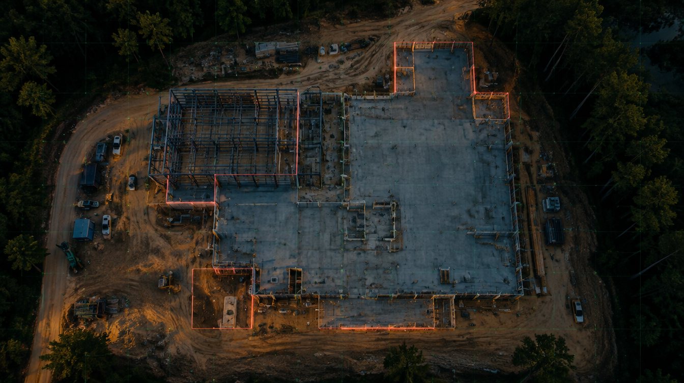
Make progress visible and verifiable. Recurring captures from the same points every visit, side-by-side comparisons and an organized project history, so ownership always knows where the job stands.
  • Recurring progress captures
  • Repeatable flight paths
  • Pre-construction baseline
  • Visit-to-visit comparisons
  • Progress time-lapse
  • Erosion control and stormwater imagery
  • Closeout records
  • Single visit or monthly schedule
Overhead view of a construction site at dusk with the areas that changed since the last visit outlined.
02 · WHAT WE DELIVER

Intelligence

Turn what we collect into decisions. AI-assisted change detection between visits, 3D site models, 360 walkthroughs and reports a decision-maker can act on. Anything that has to be measured goes to a licensed surveyor.

  • AI-assisted change detection
  • Visit reports
  • 3D site models
  • Full-site overhead imagery
  • Interior 360 before drywall
  • Ground-level 360 documentation

VISUAL RECORD, BUILT FROM GPS POSITION

Contour lines of Northeast Florida terrain.
03 · WHAT WE DELIVER

Showcase

Make the asset more compelling. Photography, video and aerial storytelling for commercial property and real estate listings, built to draw qualified buyers and tenants.

  • Commercial property photo and video
  • Aerial stills and video
  • Roof and facade condition imagery
  • Storm and damage documentation
  • Real estate listing media
  • Twilight sessions
01 / 03
HOW WE WORK

How we work

We put your site on a schedule and stay with it for as long as the project runs.

01

Capture. We set the shot list with you.

We learn the schedule, walk the site with your team and agree on the angles and how often we come back.

02

Interpret. Every visit is compared to the last.

Each set lines up with the one before it, AI-assisted change detection flags what's different, and you get a short report with the photos.

03

Monitor. We stay on it.

Visits repeat on schedule for the life of the project, quoted per site by how often we come back.

WHY VANTERA AERIAL

Built for the decision

Vantera Aerial treats every site visit as collection for a decision. We learn what the project team needs to know, capture the same points every visit and report what changed, so the people responsible for the job can act early.

We start with your questions.

How are you documenting progress today? How fast can you answer ownership? We build the visit plan around what you need to know.

The same shot list every visit.

Every visit follows the shot list set on day one. Files are sorted by visit date and delivered on the agreed schedule.

Reports you can forward.

Photos come back sorted by date with a short summary of what changed, ready to send to an owner or a stakeholder.

Map of the seven Northeast Florida counties Vantera Aerial serves: Nassau, Duval, Clay, St. Johns, Putnam, Flagler and AlachuaAlachuaNassauPutnamSt. JohnsDuvalClayFlagler
COVERAGE

Where we work

Vantera Aerial works in St. Johns, Duval, Clay, Putnam, Flagler, Nassau, and Alachua counties, including Jacksonville, St. Augustine, Orange Park, Palm Coast, and Gainesville.

Outside these counties, ask. Travel is usually workable.

AlachuaNassauPutnamSt. JohnsDuvalClayFlagler
LISTING PACKAGES

Listing packages

Four listing packages, priced by the home's listed size. Pick one and book the date online. Delivered in 24 to 48 hours from the shoot.

Low Pass

From $275

The listing, covered

  • Listing photos
  • Drone photos
Order online →

High Pass

From $495

+ Everything in Low Pass

  • 360 panoramas of the main rooms
  • Vertical social reel
Order online →

Golden Hour

From $1,095

+ Everything in Full Orbit

  • Real twilight photos
  • For homes over 5,000 sq ft
Order online →
FAQ

Common questions

What does Vantera Aerial actually deliver?

A dated, organized record of your site and a short report on what changed since the last visit. The photos, video, 3D models and 360s are the raw material. The product is knowing where the job stands.

How do you use AI?

We use AI-assisted analysis to compare each visit with the last and flag visible changes for your report. It works from photos, so it shows what changed, not measurements.

Can you fly near the airport or the Navy bases?

We check the airspace for every site before we quote it. Near an airport we request FAA authorization through LAANC, the FAA's automated approval system, which usually comes back in minutes. Areas around NAS Jacksonville and Mayport can need extra coordination, and we'll tell you up front if a site can't be flown.

Will you fly over my crews?

FAA rules limit flying over people, so we plan flight paths around active crews and check in with the superintendent before every visit.

Do I need to be on site?

No. We check in with your site contact, follow your site safety and PPE rules, and fly.

What happens if the weather is bad?

We reschedule at no cost. On a recurring schedule, the visit moves to the next workable day.

Can you add us to your insurance certificate?

Yes. We'll name your organization as additional insured on our $1 million liability certificate at no cost, and carry higher limits when a contract requires them.

Who owns the photos and video?

You do. Use them however your project needs. Vantera Aerial may also show the work in its own marketing.

Can you work with our surveyor or engineer?

Yes. Our photos and 3D models show what the site looked like. Your surveyor handles anything that has to be measured, and we can share files with them directly.

What do you need from us to get started?

The site address, your schedule, a site contact, and any access or safety requirements.

GET IN TOUCH

Request a quote

Tell us about the site and what you need to know. We'll reply with a scope and a price.

hello@flyvantera.comST. JOHNS COUNTY · NORTHEAST FLORIDA